A 23-Year-Old Built an App That Routes You Through Shadows. It Hit No. 1 in a Week.
Yoo Min-jun made it because his walk to campus was unbearable. It calculates the sun's angle and the shadows thrown by buildings and street trees for the minute you'll actually be walking, and tells you which side of the bus to sit on. It cost him about ₩2 million of his own money. Meanwhile the state has 93,375 cooling shelters — and on the hottest Sunday of the summer, four in five of Seoul's were locked.
The walk from his lecture hall to the subway was the part Yoo Min-jun used to enjoy.
He had just finished military service and was up at Seoul National University a few times sorting out re-enrolment. Twenty-three years old, a maths-education undergraduate. And that walk — the one he used to take to unwind after class — had become unbearable.
"수업이 끝나고 힐링 삼아 지하철역까지 걷던 길이 너무 뜨겁게 느껴졌다. 그때 '이제 진짜 (앱을) 만들어봐야겠다'고 생각했다"
"The walk to the station I used to take to unwind after class felt unbearably hot. That's when I thought — right, I actually have to build this."
He built it. On 18 July it went on the App Store. On 6 August it was the number one free app in Korea.
He found out because a friend sent him an Instagram post.
What it actually does
The app is called 그늘로 — "to the shade" — and the thing that makes it more than a gimmick is that it does not simply prefer parks.
It computes the solar altitude for the time you will actually be walking, then models the shadows thrown by buildings and street trees, and solves the route for shade. Critically, it does not apply one departure time to the whole journey: each walking leg is calculated for the sun position at the minute that leg is predicted to begin. If a stretch falls after dark, it drops the sun cost entirely and optimises for gradient, stairs and crowding instead.
Then there are the details that give it away as something built by a person who actually walks places.
On a subway leg it prints two badges: ❄ 약냉방 4-1~4 / 7-1~4 — the door numbers for the weak-air-conditioning cars — and ☀ 오른쪽 추천, which side of the train to stand on. On a bus leg: ☀ 왼쪽 창가 추천 · 그늘 77%. Left-hand window seat, 77% of the ride in shadow.
And on a 120-metre walk between Dongdaemun Design Plaza and exit 8, it prints, flatly: 그늘 우선 경로 적용 · 0%.
Shade-priority routing applied. Nought per cent available. The app tells you when it has nothing to offer, which is a design decision most products would not make.
There is also a loop-course generator for runners that ranks routes by shade ratio, and — added after a user asked for it — a reverse mode that finds the sunshine, for winter.
The four-minute test
A Korean news outlet ran the obvious experiment on 7 August, walking 1.2km in Seoul at around one in the afternoon with the feels-like temperature near 40°C.
Standard map app: 17 minutes, and the reporter arrived soaked.
그늘로: 21 minutes — four minutes longer — routed off the main road into back alleys where a run of three-storey houses threw shadow across the entire width of the street for about fifty metres, with no sun on her face at all.
Her verdict is the best line anyone has written about this app:
"'가장 빠른 길'은 아니었지만 폭염 속에서는 '가장 덜 지치는 길'에 가까웠다."
"It wasn't the fastest way. In a heatwave it was closer to the least exhausting way."
She also hit a construction closure the app didn't know about, and found stretches marked green that were in full sun. It is not magic.
He is not the only one
This is the part that turns a nice app story into something about how things get built now.
Yeom Ji-seok, 26, a working developer, was waiting for a friend outside, ducked into an air-conditioned bus shelter by chance, and thought about it:
"요즘 밖에서 누구 기다리다 보면 진짜 녹을 듯이 더워 에어컨 나오는 정거장만 모은 지도를 만들었다"
"Waiting for someone outside these days you feel like you're actually melting, so I made a map of nothing but the stops that have air conditioning."
His map, 에어컨 정거장, now covers around 390 locations across Seoul and Seongnam — enclosed air-conditioned bus shelters, cooled subway refuges, outdoor cooling installations, and points where free bottled water is being handed out, including whether the water has already run out so you don't make a wasted trip.
How long did it take?
"완전히 AI 바이브 코딩으로 진행해 순수 개발 시간은 3일 정도 걸렸다"
"It was pure AI vibe-coding — actual development time was about three days."
And his summary of what has changed:
"AI가 잘 나오면서 개발 진입장벽이 정말 낮아졌다. 예전에는 다른 분야를 배우려면 1~2년씩 걸렸지만, 이제는 바이브 코딩으로 금방 만들 수 있다. 무엇보다 귀찮음을 이겨내는 '실행력'이 가장 중요한 요소가 된 것 같다"
"AI has got good and the barrier to building has genuinely dropped. Learning a new field used to take a year or two; now you can make it fast. More than anything, the deciding factor has become execution — beating your own can't-be-bothered."
A third project, by an anonymous outfit, has put all 60,879 government-registered cooling shelters on a single map, flagged for whether each has air conditioning and whether it opens at weekends. Its author's stated principle, posted on the site:
"상황에 몰려 검색하는 사람에게 필요한 것은 설명이 아니라 답"
"What someone searching in a desperate situation needs is not an explanation. It's an answer."
Yoo used ChatGPT Codex and Claude to move faster. All three built on public open data — building footprints and heights from the transport ministry, street-tree positions with estimated canopy size, city bus-shelter APIs, the disaster agency's shelter registry.
What it cost, and what broke
None of this is a fairy tale, and the friction is the most useful part of it.
It was iPhone-only for most of the story. The Android build was stuck in review through the entire viral week and only went live on 12 August. Korea is roughly two-thirds Android. This app reached number one on a third of the country's phones.
It fell over. On 4 August — the day Seoul went under its first-ever top-tier heat alert — around 20,000 people arrived at once and some couldn't connect. He described the experience as feeling completely at sea.
It has cost him about ₩2,000,000 of his own money, roughly $1,400, and he says advertising revenue does not cover the servers.
"자본 없이 저 혼자 쓰려고 시작한 앱이다 보니, 유료 서비스를 구독하거나 협의해서 퀄리티 높은 자료를 얻을 수가 없었다"
"I started it alone with no money, just for my own use, so I couldn't subscribe to paid data or negotiate for high-quality material."
And the data fought him, in a way that says something about Korean open data generally:
"보행망 데이터가 전국 단위로 통일되지 않고 지자체별로 흩어져 있는 점은 아쉬웠다"
"Pedestrian-network data isn't unified nationally — it's scattered across local governments. That was the frustrating part."
Street-tree shade only exists where a local authority has published tree data, so tree shading is patchy by district rather than national. Walking-only routes are capped at 5km. There are no live bus arrivals. Reviewers complain that tree-covered stretches don't register, that the map lags when you pan, that shadows vanish when you zoom in, and that the voice guidance can't be muted and talks over your music.
It carries 4.42 stars from 43 ratings against roughly 65,000 downloads. Forty-three ratings. We're not going to dress that up.
One assumption it did defeat: it works outside Seoul. "지방은 안될줄 알았는데 잘 되네요" — "I thought it wouldn't work in the provinces, but it works fine."
Meanwhile, the state
Korea has not been idle about the heat. Quite the opposite: the country now operates 93,375 cooling shelters, up from 67,459 last year. That is nearly 26,000 new refuges in a single year, a 38% expansion, and the definition has been widened to include bank branches, railway stations, public libraries and convenience stores. About 13,000 stay open into the night when an alert is running.
It is a genuinely large piece of public infrastructure, delivered fast.
Now look at what happened to it on Sunday 2 August — the day Yangsan recorded 42.5°C, the highest temperature ever measured in Korea.
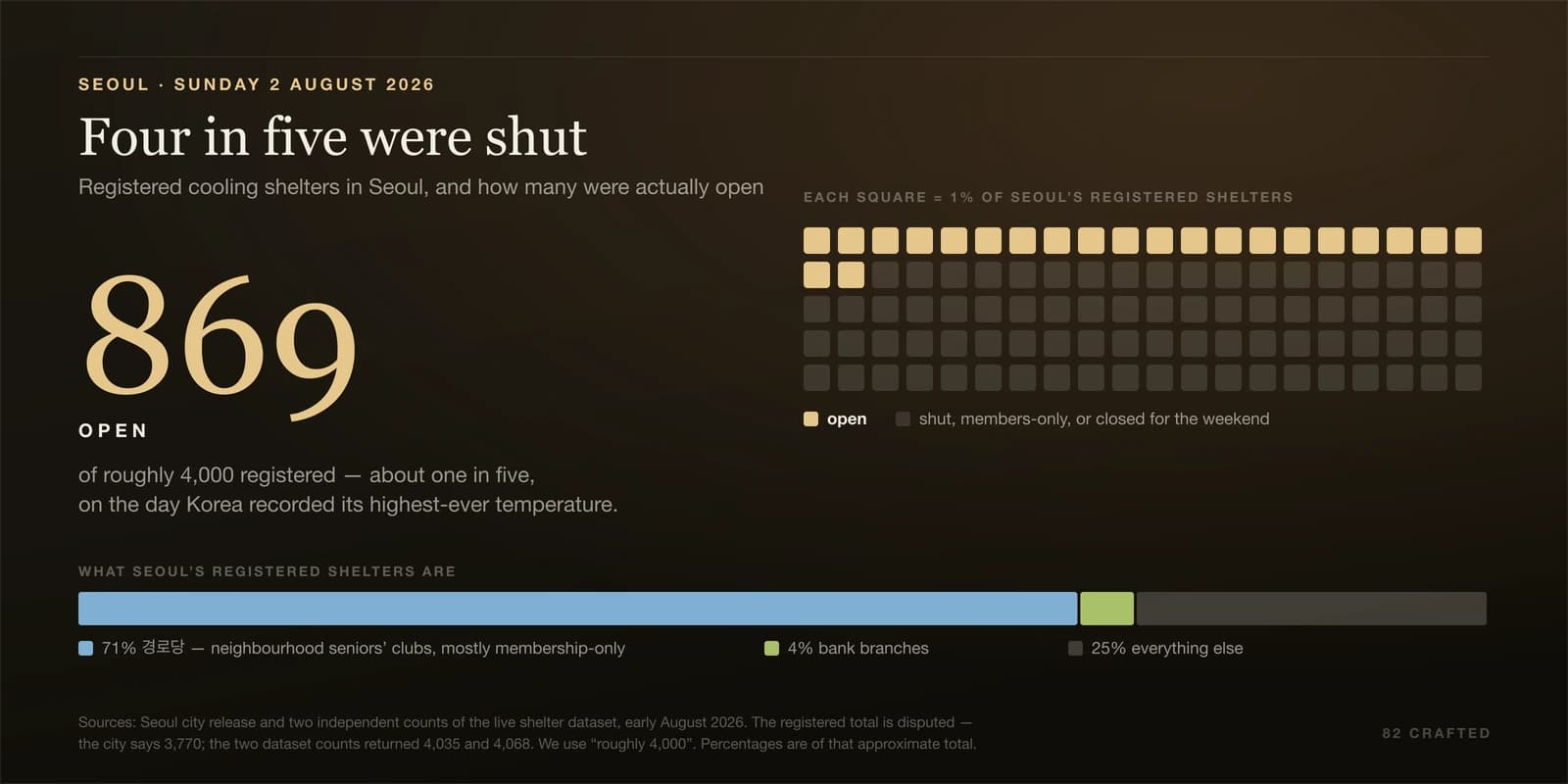
Of Seoul's roughly 4,000 registered cooling shelters, 869 were open. About one in five.
The reason is structural rather than negligent. Around 71% of Seoul's shelters are 경로당 — neighbourhood seniors' clubs, most of them membership-based, and only a small fraction have secured member consent to admit the general public. Another 4% are bank branches, which close when the bank closes. Exactly one non-government site in the city is open around the clock.
And the government's own inspectors already knew there was a problem. A joint sweep of the shelter network in April and May found roughly 1,700 deficiencies — missing signage, facilities unusable in practice, and incorrect location data.
Wrong coordinates. In the registry that the volunteers were downloading to build their maps.
The hill
The sharpest illustration is a hillside in Seodaemun-gu. On 6 August, with Seoul at 37.9°C, one of the city's last hillside shanty districts had its designated cooling shelter at the top of the slope. It has about fifty registered members. That afternoon, seven people were inside. Last year it stayed open until nine at night during the heat; this year it closes at four, because too few people were coming.
Everyone under 65, and everyone living further down the hill, has a fifteen-minute walk to the district office instead.
The same afternoon, Tapgol Park in Jongno was full of elderly men sitting under the trees, on benches and on mats spread on the road — choosing tree shade over indoor shelters that were shut, or members-only, or that they simply did not know were there.
Which is the whole thing, really. The state built 26,000 new shelters this year and four in five of Seoul's were locked on the hottest Sunday of the summer. A 23-year-old spent two weeks and ₩2 million and told people which side of the pavement to walk on.
Both of those are true, and only one of them was designed.
What he actually wants
Asked what he hoped for, he did not say scale or funding.
"길찾기가 단순히 '가장 짧은 길'을 보여주는 것이 아닌, 각자에게 편한 경로와 방식으로 이동하게 해주는 서비스가 되기를 기대한다" … "장기적으로는 도시의 그늘 접근성이나 보행환경 등을 개선하는 데 도움이 되는 서비스로 성장할 수 있으면 좋겠다"
"I hope navigation becomes a service that moves each person by the route and the method that suits them, rather than simply showing the shortest path. Long term, I'd like it to grow into something that helps improve a city's shade access and its walking environment."
And the review that got to him was not from a commuter like himself:
"어르신, 유모차를 끌거나 아이와 함께 걷는 부모님들이 활용해서 좋다는 후기도 마음이 따뜻해지는 경험이었다"
"Reviews from older people, and from parents pushing strollers or walking with a child, saying it helped — that warmed my heart."
He goes back to class in September.
For the weather that caused all this, see Korean summer, explained. For how Korea's mapping apps got to be the way they are — and why Google Maps still can't do turn-by-turn here — see our honest guide to Korean travel apps.
Images. Listing card — an officially designated 무더위쉼터, a cooling centre, signposted on a Korean street in July 2026; photograph by Monotaxism, CC0, via Wikimedia Commons. Cover and hero are charts we built ourselves: Seoul's shelters open on Sunday 2 August, and Yangsan's five-day climb to 42.5°C. Two deliberate honesty measures are drawn into the artwork rather than buried in a footnote. The Seoul waffle uses 100 cells for percentages, not 4,000 for shelters, because the denominator is genuinely disputed — the city says 3,770 and two counts of the live dataset returned 4,035 and 4,068. And the temperature chart is a dot-and-stem plot on a scale starting at 39°C, labelled as such in the frame, because the whole range is 2.2°C and drawing it as columns from zero would have been a lie in either direction. We also left out a 'previous record' reference line we wanted, because two credible sources give two different previous records.
And the honest gap, which is a large one: we cannot show you the app. Its developer's published terms grant a personal, non-commercial licence only, and the App Store's promotional-image terms require such images to sit beside a download badge on a page promoting the app — neither of which covers an article like this. So the piece's own subject goes undepicted, and the alternative would have been to take the screenshots anyway on the grounds that they are easy to fetch. Publication is not permission. There is also no free photograph anywhere of the thing the app actually routes you toward — street-tree shade over a Korean pavement, or a crosswalk 그늘막 — so that is missing too.
Reported from Korean-language coverage published between 5 and 12 August 2026, and from the apps' own store listings, which we examined directly. The app's ranking is stated precisely: number one on the Korean App Store's free chart on 6 August, and second on 7 August, with one outlet reporting it at the top for six consecutive days from 4 to 9 August. We do not say it "beat Google Maps," although that is the widely repeated framing — no source we found names the apps it outranked, and we are not going to assert a specific comparison nobody actually reported. Quotations are from written interviews given to 국민일보 (5 August), 동아일보 (8 August) and 파이낸셜뉴스 (11 August), and from the developers' own public posts; the walking test is 뉴시스, 7 August. App behaviour — the weak-air-conditioning car numbers, the per-leg sun calculation, the 0% shade readout — was verified against the official store screenshots rather than taken from press description. The 93,375 shelter figure is the number in operation this season, not an announcement made on 12 August: the same figure was already published in June, and the build-out happened across the season. Seoul's shelter count is given as "roughly 4,000" because the city's own release says 3,770 while two independent counts of the live dataset in early August returned 4,035 and 4,068 — a discrepancy we could not resolve and which is itself part of the story. Deliberately omitted: the developers' military-service dates, where two written interviews with the same person give different answers; a link to two of the three projects, whose URLs we could not confirm; and the developer's contact address, which Korean e-commerce law requires the Play Store to publish and which has no place in an article.
Keep Reading
More Stories

Korea Now Scans Every Image Uploaded to Its Big Forums. The Man Running One of Them Can't Tell You If It Has Ever Worked.
Since 1 July, Korean platforms above a size threshold must run every uploaded image through an AI filter that checks it against a government database of illegal recordings and blocks it before it posts. One operator published his own logs. Over a full year of the earlier video version, 1,615 blocks resolved down to about 33 that might have been real — and he cannot tell you whether any of them were, because keeping the files in order to check them would break a different law.
Korea Has Until December to Uninstall Twenty Years of Its Own Banking Software
In October 2025 the government finally ordered the security programs off your computer, and banks have until year-end to comply. Along the way: a cipher whose famous justification expired before it shipped, a mandate that was never in the law everyone blames, and a bank page that still uses a legal term abolished five and a half years ago.

Korea Lost 16,000 PC방 and the Industry Got Bigger: The Gaming Café, Explained
Korea had 23,548 PC방 in 2001 and fewer than 7,000 by 2025 — while the industry's revenue rose 12.8% in a single year. A look at the strangest small business in Korea: one whose price hasn't moved in 25 years, that pays rent to game publishers by the hour, and that operates under a curfew most English coverage thinks was repealed.
The Weekly Dispatch
Korea, curated. Every week.
The best of K-culture, straight from Seoul. Written by people who actually live here.
Free, no spam, unsubscribe whenever.